Moskito is a product of the company Moskito Geo-Informations-Systeme GmbH.
His origin lies in the Geographical Informations system (G SHARP) Gradis2000 for VMS machines. This appears above all in the narrow structural and functional support of this system what permits a free from problems change.
However, Moskito is no easy Portierung of the old system, but rather his logical advancement. Thus Moskito was created especially for the PC surroundings. By the development of the new draught for the internal data position and data processing the old loads of the system were able to do Gradis2000 (in the meantime, now, nevertheless, about 20 years old!) are abandoned. This was moved without destroying the outwardly visible, structures grown in practice and profiles.
As an example of the functional supplement of the system towards Gradis2000 only the grid data processing and the WYSIWYG conversion would be called here.
Still it concerns with Moskito still a young system which is in the development and which leaves open at the moment still deliberately the possibilities of an enlargement oriented to user and supplement to themselves.
Here exists the possibility to integrate your special problem formulation individually into the draught of Moskito.
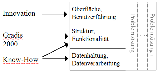
Illustration 1
Moskito ties together therefore well-tried with new know-how and perhaps your special problem solution on contemporary working surroundings.