The transformation files in which similarly to TIFF-Worldfiles grid co-ordinates and geocoordinates are given to the representation appropriate for situation of the accompanying grid data can be put on with this dialogue. The Eintransformieren of grid data with this method makes sense only if the grids achsparallel are to the aim co-ordinate system and if the same length width relation to the target system exists.
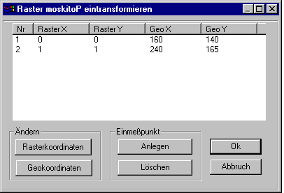
The contents of the transformation file of the open grid element are indicated in a dialogue field. The file carries up to the ending which is aberrantly ".tra", the same names like the grid file. If the transformation file does not exist yet, it is put on. In the title of the dialogue field the name of the grid file, in the above example "moskitoP", is included.
Before changing from Grid co-ordinates or Geocoordinates of a passport point the suitable line must be selected by clicking the number. The change of co-ordinates works up to the choice of another or putting in or extinguishing of a passport point on this line.
With the badge Put in if a new passport point is generated and indicated. The suitable line is automatically selected, so that his grid co-ordinates and geocoordinates can be worked on immediately.
Before him Extinguish of a passport point the suitable line must be selected by clicking the number. The point is extinguished without further inquiry.
With OK if the contents of the dialogue field are written in the transformation file and the dialogue is finished. Demolition finishes him without change of the file.