Function to read in and situation-right positioning of TIFF files to which already TIFF-Worldfiles (.twf) or Moskito-transformation files (.tra) exist, or, however, from the TIFF files which fulfil the following conditions:
The grid must be achsparallel to the desired co-ordinate system, have the same resolution in X and Y direction and may show no annoying edge areas (e.g., coscanned frames, legends, etc.).
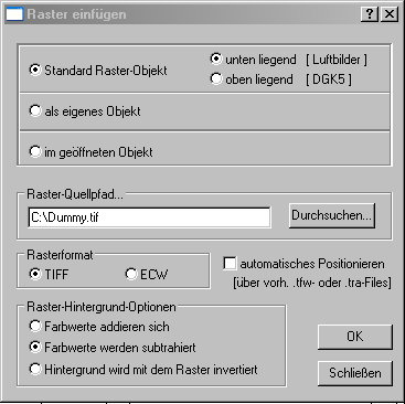
In the upper area of the dialogue window it is fixed whether the grid as an element in own object (object keys brag!) or should be inserted in the open object.
Under it the grid-source path is given. The searching button can be used comfortably for it. The path should contain no blanks.
As a grid format the TIFF format is to be chosen as a rule.
Exists in the same list like of the grid file also accompanying.twf-or tra file, the grid is situation-properly positioned by clicked option „automatic positioning“ immediately accordingly.
In the lower left area can be fixed how the colour values of the grid should behave to those of the background. The middle option is preset normally „Colour values are subtracted“.
The function is begun by operating the OK-button. Condition is that a plan is opened, the path is right (without blank) and the format is properly given.
If the option „automatic positioning“ was chosen, the grid picture is loaded and indicated immediately at the suitable place – presumed, suitable.tra-or.twf file exists in the same list. There occurs a zoom on the grid object.
If the option „automatic positioning“ was not chosen, now the user is asked over the command window to digitize two (diagonally opposite) corner points for the temporary positioning of the grid (best of all something beside the desired position). The grid picture appears at the aforesaid place and it opens the dialogue window to the construction of the transformation file to itself (watch help Extras|Raster|Eintransformieren) and the input of the grids and geo-co-ordinates the transformation can be carried out interactively on the screen. If then with the OK-key the given co-ordinates are confirmed, the grid is indicated at the suitable place. Should no transformation occur immediately, the transformation can be also let out with the cessation key. The transformation file also is able afterwards about the dialogue under Extras|Raster|Eintransformieren again are changed.